DJI, the drone market leader, has rolled out the Geospatial Environment Online (GEO) 2.0 system that will create a buffer zone around no-fly zones such as airports.
DJI said customers must update their DJI GO 4 flight control app and aircraft firmware for the updates to take effect.
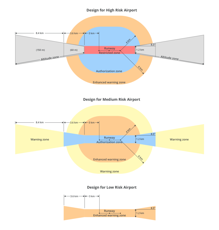
Geofencing is integrated into all DJI drones, and uses GPS positioning and other navigational satellite signals to warn or restrict drone operators from entering locations which pose security or safety concerns.
The ‘bow tie’ shape prevents drones from entering an area where traditional aircraft fly, while creating flexibility for operators authorised by the aviation authority to work safely within close proximity to runways. For example, areas around the side of runways, as well as low-altitude locations more than three kilometers from the end of a runway, are outside the direct flight path and are considered safe zones.
The GEO 2.0 system won’t create a great difference to DJI drone operators who play by the rules and steer clear of airports. But it has been welcomed by Australia’s Civil Aviation Safety Authority, which oversees drone regulation and is under immense pressure from politicians to further restrict drone usage.
‘CASA is supportive of manufacturer’s efforts to use technology like geofencing to help drone flyers operate lawfully and safely,’ said Luke Gumley, CASA branch manager of Remotely Piloted Aircraft Systems. ‘The release of DJI’s new GEO 2.0 system is welcomed and demonstrates a commitment to aviation safety.’
CASA is planning to tighten recreational drone regulation and introduce a registration fee system for commercial operators this year.
The GEO 2.0 system covers two dozen countries in the Asia-Pacific region, including Australia.
DJI says it pioneered geofencing for drones, as well as automatic altitude limitations, obstacle avoidance systems and various other features that promote safe drone operation.
Recreational drone safety has become a major concern for aviation authorities around the world, as the increased popularity in the technology heightens the possibility of a catastrophic accident.
Already a rogue drone operator has grounded fire-fighting helicopters in Bruny Island, Tasmania; and a high-profile drone incident at Gatwick Airport in the UK led to the delay of over 1000 flights.


Be First to Comment